If you’re looking for Patna District Complete Information, this guide gives you everything you need — geography, history, population, administration, development projects, and more. Patna, the capital city of Bihar and the headquarters of Patna district, is a unique blend of ancient heritage and modern growth. From being the seat of great empires like the Mauryas and Guptas to becoming a hub for infrastructure development, Patna district plays a key role in eastern India. Below is a complete, structured breakdown of the district’s profile in a way that is informative, easy to navigate, and updated.
Geographical Profile of Patna District
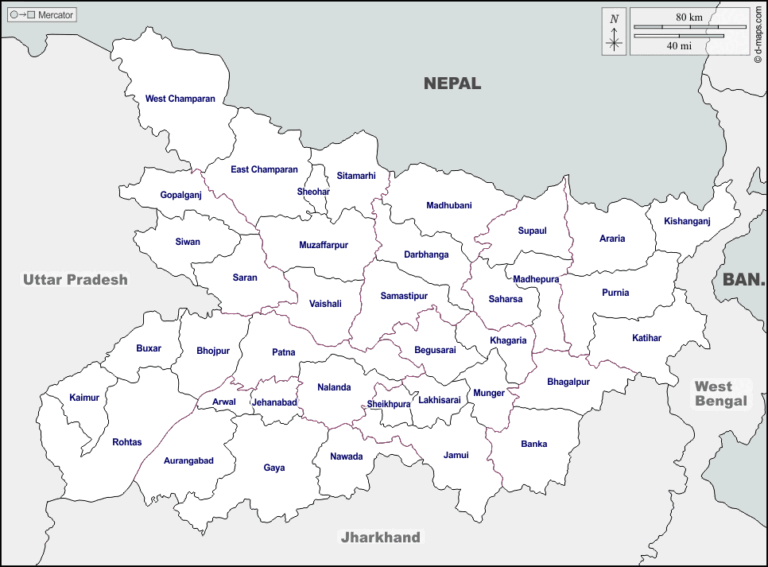
Location & Area
- Patna district is located in the state of Bihar, eastern India.
- Total area: Approximately 3,202 sq. km
- It lies mainly on the southern bank of the Ganga River.
Boundaries
- North: Bounded by the Ganga River
- East: Lakhisarai District
- South: Nalanda and Jehanabad
- West: Bhojpur District
Soil and Terrain
- Alluvial plains dominate the region.
- Two major agro-climatic zones: Diara (riverine) and Tal (low-lying floodplain).
- Subject to annual monsoon floods.
Administrative Setup
Sub-divisions and Blocks
- The district comprises 6 sub-divisions:
- Patna Sadar
- Patna City
- Danapur
- Barh
- Masaurhi
- Paliganj
- 23 Community Development Blocks
Panchayats and Villages
- Over 344 Gram Panchayats
- Approximately 1,433 villages, with 1,294 inhabited
Demographics of Patna District
- Total Population (2011 Census): 5.84 million
- Urban: 2.51 million
- Rural: 3.33 million
- Literacy Rate: 70.68%
- Sex Ratio: 897 females per 1,000 males
Religion and Language
- Religions:
- Hindu – 91.74%
- Muslim – 7.54%
- Others – <1%
- Languages Spoken:
- Hindi (official), Magahi, Bhojpuri, Urdu
Historical Significance
Ancient History
- Ancient name: Pataliputra
- Capital of major Indian empires: Maurya, Gupta, and Magadh
- Associated with historical figures like Chanakya and Aryabhata
Colonial and Modern Era
- Became a district under British India in 1770
- In 1972, Nalanda was carved out of Patna district
Economy and Agriculture
If you’re studying Patna District Complete Information, you should know agriculture is its economic backbone.
Main Crops
- Rice (primary)
- Wheat, maize, pulses, oilseeds, and vegetables
Irrigation and Challenges
- Mostly rain-fed farming with limited canal and tube-well irrigation
- Issues: seasonal flooding, poor drainage in Tal areas
Major Infrastructure and Development Projects
Bihta Dry Port
- India’s first dry port in Bihar
- Located in Bihta; launched in October 2024
- Boosts international trade and cargo handling
Jay Prakash Narayan Airport Expansion
- New terminal inaugurated in May 2025
- Annual capacity: 10 million passengers
- New cargo terminal with cold storage opened in Feb 2025
Road and Drainage Projects
- ₹181 crore Rajiv Nagar drainage road
- ₹91 crore Anandpuri road over drain
- ₹197 crore 4-lane road from AIIMS Patna to Danapur
Education and Research Institutes
Patna District is an educational center in Bihar.
Major Institutions
- Patna University (1917)
- IIT Patna
- AIIMS Patna
- NIT Patna
- Chanakya National Law University
Science Promotion
- New interactive science centers
- STEM education boosted via Smart City initiatives
Tourism and Cultural Importance
Historical Monuments
- Kumhrar – ruins of ancient Pataliputra
- Golghar – British-era granary
- Agam Kuan – ancient Ashokan well
Religious Sites
- Takht Sri Harmandir Sahib – Sikh shrine
- Mahavir Mandir – Hindu temple
- Padri-Ki-Haveli – Bihar’s oldest church
Law & Order
- Patna Police handle law enforcement under Bihar Police
- Issues include urban crime, encroachments, and traffic congestion
- Surveillance: Wide CCTV networks and traffic monitoring systems
Urban Development and Smart City Projects
Patna is part of India’s Smart City Mission, a key point in Patna District Complete Information.
Key Initiatives
- E-governance platforms
- Smart street lighting
- Underground drainage
- Public Wi-Fi zones
Patna Metro
- Under construction
- Will connect Danapur to Khemni Chak
JP Ganga Path
- Riverfront expressway along the Ganga
- Cycle paths, double-decker buses, public gardens
Summary Table: Patna District Key Facts
| Parameter | Details |
|---|---|
| Total Area | 3,202 sq. km |
| Population (2011) | 5.84 million |
| Literacy Rate | 70.68% |
| Main Crops | Rice, wheat, maize, pulses |
| Administrative Units | 6 sub-divisions, 23 blocks |
| Major Institutions | IIT, AIIMS, Patna University |
| Historic Name | Pataliputra |
| Development Projects | Bihta Dry Port, Patna Metro |
Conclusion
This guide offers Patna District Complete Information in a structured and detailed manner. Whether you’re a student, traveler, policymaker, or resident, knowing about Patna’s geography, history, demographics, economy, and infrastructure gives you a full picture of one of Bihar’s most important regions. From ancient empires to smart cities, Patna continues to be a center of growth and legacy in eastern India.
FAQs
1. What is the total area of Patna District?
Patna district covers approximately 3,202 square kilometers, making it one of the largest districts in Bihar in terms of administrative and population density.
2. Why is Patna historically significant?
Patna, formerly known as Pataliputra, was the capital of ancient empires like Maurya and Gupta and home to scholars like Chanakya and Aryabhata.
3. What are the major crops grown in Patna district?
The key crops are rice, wheat, maize, pulses, and vegetables, with rice being the staple and dominant crop across the district.
4. What are some major development projects in Patna?
Major projects include the Bihta Dry Port, Patna Metro, Jay Prakash Narayan Airport expansion, and JP Ganga Path (Riverfront Expressway).
5. How is Patna district divided administratively?
Patna has 6 sub-divisions, 23 blocks, and over 1,400 villages, with key sub-divisions like Danapur, Barh, and Patna Sadar.